
Drone first responder: Hilliard police working with prototype 'game-changer'
A. Kevin Corvo - This Week News • April 26, 2021
CAL Analytics develops air traffic management system for DFRs (Drones as First Responder)
The Hilliard Division of Police is testing a prototype drone first responder being developed by Hilliard-based Converge Technologies in a collaboration that is "a game-changer in every response,” Deputy Chief Eric Grile said.
Hilliard police have been using drones since 2019, but they are deployed only after officers arrive at a scene. They also have limited applications because the Federal Aviation Administration requires drones to be visible at all times to operators or to a human in radio contact with an operator.
The goal is to do incremental testing to improve the capabilities of drone first responders, earn FAA certificates of authorization after each test and to eventually achieve the ability to operate DFRs using electronic visual lines of sight, Grile said.
“At this stage, it is a development partnership” and there is no pending contract for the lease or purchase of DFRs, he said.
Converge Technologies, 4621 Lyman Drive, with support from other companies housed there, is developing the means for drones to safely fly to emergency scenes, avoiding birds, trees, other drones, and any other obstacles, said John Bair, the company’s chief executive officer and chief technology officer.
He said Converge Technologies is building the platform for DFRs, but other companies are contributing to all the parts and pieces needed to achieve the goal of getting FAA approval for drones to fly using electronic visual lines of sight.
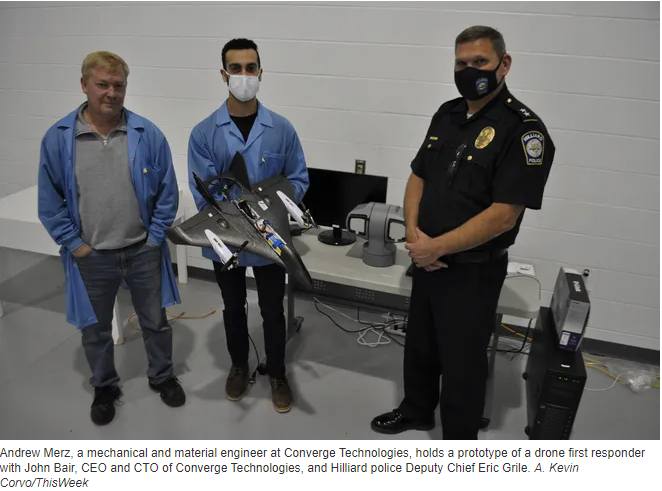
Andrew Merz, a mechanical and material engineer at Converge Technologies, holds a prototype of a drone first responder.
GhostWave is developing the radar system for the DFRs; Lighthouse Avionics builds the towers necessary for the autonomy of the drones and establishing an electronic visual line of sight; Cal Analytics is building the management system or “flight control” for the DFRs; Axis Communications makes ground-based or tower-mounted cameras for tracking the DFRs; and Ubihere will establish the protocols or the “brains” of the DFRs, Bair said.
“It’s a collaborative effort, (and) it’s a minimal one-year process,” he said.
The companies involved in developing the drone first responders have received grants from the Ohio Federal Research Network and other agencies, Bair said.
"There are a lot of moving parts to this project with a lot of support from a number of private, state and federal agencies," Bair said. "To complete the entire system will take more investment over the next couple of years."
Besides $2.6 million in funding from the OFRN, the project also has received funding from Small Business Innovation Research, Small Business Technology Transfer, and Technology Validation Startup Fund.
The OFRN grant allowed GhoseWave to invest $1.2 million to develop the radar-threat detection system and Cal Analytics to invest $1,4 million to develop the air-traffic management system.
The SBIR funded Ubihere $850,000 to develop an asset-tracking device that will be used in the towers and on the drone, and the STTR funded Ubihere $150,000 to develop the GPS-denied navigation technology to be used in the drone.
The TVSF funded Lighthouse Avionics $100,000 to develop the autonomous-drone technology.
Converge Technologies is investing an additional $500,000 to complete the DFR prototype aircraft, Cal Analytics is investing an additional $450,000, and Lighthouse Avionics an additional $500,000, Bair said.
While Converge Technologies brings the computer hardware and software to the table to perfect the DFRs, Grile said the police department brings the ability to obtain the certificates of authorization needed from the FAA to operate the drones.
Grile said the idea of using a drone in a more proactive way was born at the International Chiefs of Police conference that he and Chief Robert Fisher attended in Chicago in 2019. He said he learned that police in Chula Vista, California, use drones when responding to emergency situations, including car crashes, active breaking-and-entering incidents and in some instances, domestic disputes.
Grile said he can envision a multitude of ways in which a drone first responder could be used. For instance, he said, when a 911 is placed, an officer could deploy a DFR that could follow a direct path at speeds of up to 80 mph and reach any location in Hilliard in about a minute.
At that point, a dispatcher could choose to end the call with the person who first called 911 and begin relaying what the DFR “sees” to the officers responding to the scene.
The DFR “extends the learning curve,” for responding officers, Grile said.
The more an officer knows before arriving at a scene, the safer it is for the officer, those who called police, and the public, Grile said.
The use of a DFR also lessens the risk of vital information being missed, misunderstood, or “lost in translation,” he said.
The policies and protocols for DFRs – once finalized – must be able to be replicated so other law-enforcement agencies can use the technology, perhaps similar to how multiple police agencies began using radio frequencies, Grile said.
The collaboration between the city and Converge Technologies is an example of the benefit of having such resources in the city, Development Director David Meadows said.
“We’re always happy when the city can find ways to partner with companies like this because it shows that Hilliard is an attractive place for entrepreneurs to launch and grow their businesses,” Meadows said.
Source: This Week News
kcorvo@thisweeknews.con
@ThisWeekCorvo
COLUMBUS, OH (February 9, 2026) — Ohio continues to lead the nation in modernizing emergency response with the selection of nine public safety agencies to participate in the Ohio Statewide Drone First Responder (DFR) Pilot Program , a first-of-its-kind initiative designed to expand rapid aerial response capabilities across communities of all sizes. The program, led by the Ohio Department of Transportation (ODOT) and DriveOhio, with program management support from SkyfireAI, reflects Ohio’s commitment to equipping first responders with innovative tools that improve situational awareness, enhance officer and responder safety, and reduce emergency response times. The following agencies have been selected to participate in the pilot program: City of Springfield Police/Fire/EMS Athens Police Department Lima Police Department Toledo Police Department Violet Township Fire/EMS Austintown Fire Department City of Hamilton Police/Fire/EMS Amherst Police Department Kelleys Island Fire/EMS Together, these agencies represent a diverse cross-section of Ohio, spanning urban centers, suburban communities, and rural jurisdictions — reinforcing the program’s goal of ensuring access to advanced emergency response capabilities statewide. Many of the selected agencies have also committed to sharing drone resources with neighboring jurisdictions, further expanding the impact of this program. “Ohio is committed to giving our first responders the tools they need to protect lives and serve their communities safely and effectively,” said Governor Mike DeWine . “This statewide Drone First Responder pilot reflects Ohio’s leadership in innovation, our strong partnership with local agencies, and our focus on using technology responsibly to support public safety across the state.” Created under Ohio House Bill 96, the Ohio Statewide DFR Pilot Program enables participating agencies to deploy state-approved, NDAA-compliant drone systems capable of rapid launch, real-time video streaming to command staff, and integration into Ohio’s emerging uncrewed aircraft traffic management framework, led by Ohio-based CAL Analytics. “We are enthusiastic supporters of DFR program and thankful for the efforts of so many Ohio leaders to accelerate this program into the execution phase,” said State Representative Adam Holmes , who championed the program's inclusion in the bill. “The DFR program will greatly enhance first responder effectiveness and will provide increased support for all Ohioans. A tremendous capability for our priceless first responders.” “Ohio is leading the way for the nation with the first statewide DFR program! Our ODOT leaders are setting the stage for an integrated network of DFR assets that will undoubtedly save lives and resources and be a force-multiplier for our undermanned first responder organizations,” said State Representative Bernard Willis , Chair of the House Transportation Committee. “In Ohio, the HOME of aviation we are the BEST at making historic innovations with flying machines, and we will NEVER stop leading the way!” With technology known as drone-in-a-box, a drone can be launched from a permanent docking site and be flown remotely to a scene. These pre-positioned drones provide real-time visual information to aid decision-making, and some can also drop critical medical supplies to the scene of an emergency. The program emphasizes operational readiness, standardized training, and responsible use, while maintaining a strong focus on community engagement and transparency. “This program is about thoughtful implementation, not experimentation,” said Richard Fox, Director of the DriveOhio UAS Center . "By coordinating procurement, training, and regulatory support at the state level, Ohio is creating a scalable model that benfits communities of every size. We're grateful for the confidence the legislature has in ODOT to execute this groundbreaking program." SkyfireAI, a national leader in public safety drone program development and FAA regulatory integration, is supporting the initiative as program manager, working closely with ODOT, DriveOhio, and participating agencies to ensure consistent standards and successful deployment. “The selection of these nine agencies reflects the strength of Ohio’s public safety community and the seriousness with which this program has been approached,” said Don Mathis, Co-Founder and CEO SkyfireAI . "This pilot lays the foundation for how states can responsibly scale DFR programs today — and prepare for future capabilities as technology continues to evolve." Selected agencies will participate in a structured onboarding process beginning in early 2026, including hands-on vendor demonstrations, training, and program coordination. Operations are expected to begin in Spring 2026 and continue for approximately a year. The pilot program will evaluate operational effectiveness, response outcomes, and opportunities for future expansion. Ohio’s Statewide Drone First Responder Pilot Program has already drawn national attention as a potential blueprint for other states seeking to modernize emergency response while maintaining strong governance, safety, and public trust. ### About CAL Analytics: CAL Analytics is a small business focusing on the development of aviation and autonomous systems. Located in Dayton, OH and founded in 2010, CAL has expertise in navigation systems, remote sensing, signal analysis, and information fusion. CAL is a leader in UAS Traffic Management (UTM) and Advanced Air Mobility (AAM) technology, offering airspace management, mission management, detect and avoid, and in-time system-wide safety assurance (ISSA) solutions. Our mission is to provide agile and rigorous approaches to bring new technologies to the world. More information at calanalytics.com About SkyfireAI: SkyfireAI is an AI-native drone technology company redefining mission-scale autonomy for public safety, defense, and enterprise markets. Our cloud-connected and edge-enabled software platform powers autonomous swarming, Beyond Visual Line of Sight (BVLOS) operations, and real-time AI analytics—unlocking faster response, smarter decision-making, and safer operations. Built for scalability, SkyfireAI’s solutions deliver repeatable, high-value outcomes across thousands of missions, positioning the company to capitalize on a rapidly expanding global uncrewed systems market projected to exceed $100 billion by 2030. More information is available at skyfireai.com . About ODOT’s DriveOhio Initiative: DriveOhio is the state’s center for smart mobility, advancing connected, automated, shared, and electric transportation. The UAS Center, located in Springfield, OH, is the statewide resource for uncrewed aircraft systems testing, integration, and operations.
SPRINGFIELD, Ohio – January 27, 2026 – CAL Analytics, an innovator in advanced airspace management technologies, and AeroVironment, Inc. (“AV”) (NASDAQ: AVAV), a global defense technology leader delivering software-enabled disruptive autonomous systems, today announced the completed installation and initial operation of a new Beyond Visual Line of Sight (BVLOS) airspace management facility at the National Advanced Air Mobility Center of Excellence (NAAMCE) at Springfield-Beckley Municipal Airport in Springfield, Ohio. Initially developed under a Cooperative Research and Development Agreement (CRADA) between the Air Force Research Laboratory (AFRL) and the Ohio Department of Transportation (ODOT), the project now features an upgraded installation that integrates AV_Halo™ COMMAND, AV’s command and control (C2) architecture, with CAL Analytics’ Advanced Air Mobility (AAM) enterprise platform to establish the nation’s premiere test environment and management facility, where Department of War operators can safely conduct BVLOS missions in shared airspace utilizing existing Federal Aviation Administration (FAA) ground radar feeds. “This installation establishes the blueprint for how airports and states across the country can safely integrate uncrewed aircraft into existing airspace,” said Wahid Nawabi, Chairman, President and Chief Executive Officer at AV. “As the FAA defines the future of BVLOS rule-making, this facility provides the real-world operational data, safety validation, and interoperability framework regulators need. The system we’ve installed in Ohio isn’t just a mock-up or a test site — pending FAA approval it will be an operational and scalable model for nationwide deployment and the foundation for truly integrated air mobility.” The integration will support flight tests, evaluation, and day-to-day operations by routing AFRL’s access to the FAA’s ground-radar network through AV_Halo™ COMMAND — AV's modular, software-driven C2 architecture that fuses multiple enhanced sensor feeds, into a single, secure operating picture, giving operators continuous situational awareness for BVLOS mission planning and airspace safety. “AV_Halo is the connective tissue that turns a collection of sensors, radars, and platforms into a living, breathing airspace system,” said Stephen Lloyd, Senior Director C2, CUAS, and Tracking at AV. “By fusing FAA ground radar, and COTS surveillance sensors into a single, secure operating picture, AV_Halo delivers the assured visibility and machine-speed decision support needed for predictable BVLOS operations—and makes it possible to scale effortlessly from a single site to an entire statewide corridor.” When combined with CAL Analytics’ AAM enterprise platform, the system unifies radar and advanced DAA into a single real-time airspace view—enabling detect-and-avoid, extending autonomous BVLOS operations with precision and confidence. “Beyond Visual Line of Sight operations are the key to unlocking the next generation of air mobility,” said Dr. Sean Calhoun, Managing Director of CAL Analytics. “This facility will prove that BVLOS can be executed safely and reliably in shared airspace—and that matters because it sets the foundation for statewide corridors, national standards, and an entirely new layer of transportation infrastructure that will reshape how we move people, goods, data, and critical services across the country.” Pending full FAA approval, the facility will support local missions and real-time monitoring of UAS activity as AFRL, ODOT, the FAA, AV, and CAL Analytics collaborate to validate airspace-safety technologies, advance air-mobility corridors, drive economic development, and shape national BVLOS rules and integration standards. Plans are already underway to extend the system to enable corridors between Springfield and Columbus, Ohio, adding new radar sites and expanding detect-and-avoid coverage to support broader BVLOS operations across Ohio and additional sites nationwide.

(DAYTON, Ohio) – CAL Analytics is pleased to announce a strategic partnership with AirData UAV to integrate the Low Altitude Authorization and Notification Capability (LAANC) into AirData’s suite of drone operation services. This collaboration streamlines operations and creates safety awareness for drone pilots by providing real-time airspace data and automated authorizations for flight in controlled airspace. AirData is committed to delivering an intuitive customer experience, with CAL’s LAANC service fully integrating into its existing fleet management platform. All AirData users can request LAANC authorizations through both the AirData web portal and the AirData mobile app. “This partnership with AirData marks a significant milestone for CAL Analytics,” said Dr. Sean Calhoun, Founder and Managing Director of CAL Analytics. “By integrating the LAANC capability into AirData’s already extensive software platform, we are able to offer AirData users a seamless LAANC authorization experience, enhancing both safety and efficiency in drone operations.” CAL is an FAA-approved UAS Service Supplier (USS) of LAANC, a collaborative effort between the Federal Aviation Administration (FAA) and industry partners, providing drone pilots with access to controlled airspace at or below 400 feet. This partnership with CAL will allow AirData users to quickly and efficiently obtain necessary flight authorizations, ensuring compliance and improving operational efficiency. “Providing intuitive and straightforward workflows for our customers is of paramount importance to us,” said AirData CEO Eran Steiner. “We are thrilled to partner with CAL Analytics to deliver best-in-class LAANC services. AirData is dedicated to offering our customers seamless and comprehensive drone fleet management, encompassing everything from mission planning and pilot certifications to compliance and flight data analysis. The LAANC integration for 3rd parties like AirData is another key component of CAL Analytics’ suite of UAS airspace management services, providing critical real-time data and automated processes that support safe and efficient drone operations. This partnership underscores CAL Analytics’ commitment to advancing the capabilities of UAS and promoting safe airspace practices. AirData’s collaboration with CAL will provide a streamlined LAANC workflow for users, allowing for quick and straightforward access from a variety of devices and locations. LAANC requests can be tied into AirData’s Mission Planning tool set and are recorded in the user’s account for compliance and record-keeping. The AirData platform provides a extensive set of features that benefit the entirety of the drone flight workflow, from pre-flight checklists to live video streaming during flights, with sophisticated post-flight fleet data analytics to maximize the value and safety of drone operations. This unified fleet management approach allows customers to mitigate risk, improve fleet efficiency, and manage end-to-end compliance. About CAL Analytics CAL Analytics is focused on the development of aviation and autonomous systems. Located in Dayton, OH and founded in 2010, CAL has expertise in navigation systems, remote sensing, signal analysis, and information fusion. CAL is a leader in UAS Traffic Management (UTM) and Advanced Air Mobility (AAM) technology, offering airspace management, mission management, detect and avoid, and in-time system-wide safety assurance (ISSA) solutions. Our mission is to provide agile and rigorous approaches to bring new technologies to the world. To learn more about CAL Analytics, please visit https://calanalytics.com/ About AirData AirData is the largest online drone fleet data management and real-time flight streaming platform, serving over 330,000 users with 42 million flights uploaded to date, capturing an average of 25,000 high-resolution flight records a day. AirData is used by large fleet operators around the world as a comprehensive flight safety data analysis and crash prevention platform, with advanced maintenance, mission planning, pilot tracking, and easy-to-use live streaming. To learn more about AirData, please visit https://airdata.com/