
NUAIR Partners with CAL Analytics and FAA to Develop Methods for Certifying Detect and Avoid Services for Drone Operations
Sean Calhoun • April 21, 2022
Upgrades to New York’s 50-mile Drone Corridor helps FAA and industry unlock safe, beyond visual line of sight drone operations

(SYRACUSE, NEW YORK)
– CAL Analytics is deploying their detect and avoid (DAA) service and contingency management platform (CMP) within New York’s 50-mile Drone Corridor and Federal Aviation Administration (FAA) designated uncrewed aircraft systems (UAS) Test Site at Griffiss International Airport, managed by NUAIR. The organizations are working jointly on a Technical Assistance program with the FAA to enable and approve a DAA service for low-altitude beyond visual line of sight (BVLOS) UAS operations.
Current regulations require drone operators to always have a pair of human eyes visually monitoring the airspace in which the drone is flying, limiting the ability to fly long distances. Without being able to see the drone, the system needs the ability to detect and avoid obstacles in the air and on ground to assure the safety of both crewed and uncrewed aircraft. The ability to safely fly BVLOS is the key to unlocking the full potential and economic advantage of routine commercial drone operations like medical and package deliveries.
“This upgrade to the 50-mile Drone Corridor between Rome and Syracuse will help integrate detect and avoid technology to further the safe advancement of unmanned aircraft systems into the national airspace and unlock the true potential of commercial drone operations,” said Oneida County Executive Anthony J. Picente Jr. “We look forward to the fruit this partnership between CAL Analytics and the FAA will bear at Oneida County’s Test Site, which continues to flourish under NUAIR’s management.”
The DAA service will be CAL’s newest UAS traffic management (UTM) service being brought to market and builds off their existing contingency management platform (CMP), which provides a suite of UTM services. CAL’s CMP will offer critical airspace services, including situational awareness from Kongsberg, conflict detection from CAL, health monitoring by ResilienX, and various weather services from TruWeather Solutions to help ensure the safe operation of uncrewed aircraft.
“We’re excited to partner with NUAIR and working directly with the FAA to get our DAA service approved for small UAS,” said Dr. Sean Calhoun, managing director of CAL Analytics. “This will go a long way towards validating several of the DAA standards, including those from ASTM-F38 and RTCA SC-147, and opening the skies for safe BVLOS drone operations.”
The BVLOS flight operations will be performed by NUAIR who manages operations of the New York UAS Test Site at Griffiss International Airport in Rome, NY, one of just seven FAA-designated UAS test sites in the United States. The CAL technology will provide several key services to enabling safe BVLOS operations within New York’s 50-mile UAS Corridor instrumented with radar, communication networks, including 5G, and other leading-edge technologies that facilitate advanced drone operations.
“One of the most important recommendations from the recent BVLOS Aviation Rulemaking Committee was for the FAA to develop a methodology for approving safety-critical UTM services for BVLOS,” said NUAIR Chief Technology Officer Andy Thurling. “NUAIR is working with our partners at CAL Analytics and the FAA to do just that.”
NUAIR and its alliance of partners, including CAL Analytics, ResilienX, TruWeather Solutions and more will be showcasing their technologies and latest advancements at the upcoming AUVSI XPONENTIAL conference in Orlando, Florida, April 25-28. The companies are part of the GENIUS NY booth #1761, highlighting leading-edge companies in Central New York and taking applications for the next round of the $3 million business acceleration competition that is GENIUS NY.
###
About NUAIR
NUAIR (Northeast UAS Airspace Integration Research Alliance, Inc.) is a New York-based nonprofit with a mission to safely integrate uncrewed aircraft systems (UAS) into the national airspace, enabling scalable, economically viable commercial drone operations. NUAIR manages operations of the FAA-designated New York UAS Test Site at Griffiss International Airport, Rome, NY on behalf of Oneida County and is responsible for the advancement of New York’s 50-mile UAS Corridor between Rome and Syracuse, NY. https://nuair.org
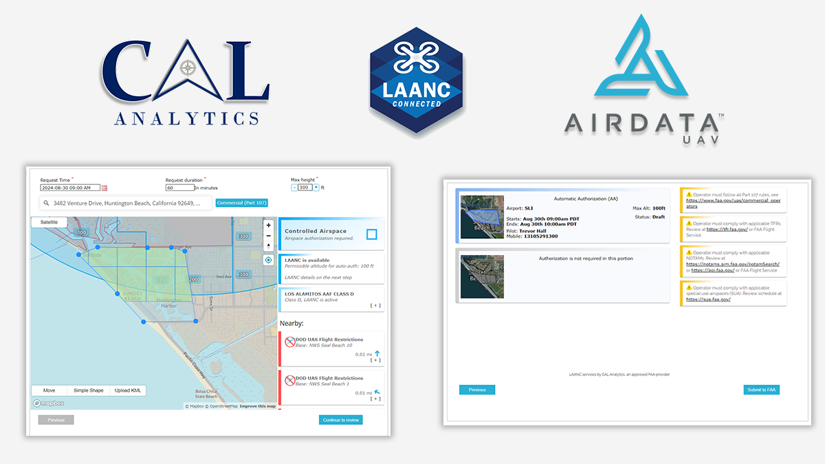
(DAYTON, Ohio) – CAL Analytics is pleased to announce a strategic partnership with AirData UAV to integrate the Low Altitude Authorization and Notification Capability (LAANC) into AirData’s suite of drone operation services. This collaboration streamlines operations and creates safety awareness for drone pilots by providing real-time airspace data and automated authorizations for flight in controlled airspace. AirData is committed to delivering an intuitive customer experience, with CAL’s LAANC service fully integrating into its existing fleet management platform. All AirData users can request LAANC authorizations through both the AirData web portal and the AirData mobile app. “This partnership with AirData marks a significant milestone for CAL Analytics,” said Dr. Sean Calhoun, Founder and Managing Director of CAL Analytics. “By integrating the LAANC capability into AirData’s already extensive software platform, we are able to offer AirData users a seamless LAANC authorization experience, enhancing both safety and efficiency in drone operations.” CAL is an FAA-approved UAS Service Supplier (USS) of LAANC, a collaborative effort between the Federal Aviation Administration (FAA) and industry partners, providing drone pilots with access to controlled airspace at or below 400 feet. This partnership with CAL will allow AirData users to quickly and efficiently obtain necessary flight authorizations, ensuring compliance and improving operational efficiency. “Providing intuitive and straightforward workflows for our customers is of paramount importance to us,” said AirData CEO Eran Steiner. “We are thrilled to partner with CAL Analytics to deliver best-in-class LAANC services. AirData is dedicated to offering our customers seamless and comprehensive drone fleet management, encompassing everything from mission planning and pilot certifications to compliance and flight data analysis. The LAANC integration for 3rd parties like AirData is another key component of CAL Analytics’ suite of UAS airspace management services, providing critical real-time data and automated processes that support safe and efficient drone operations. This partnership underscores CAL Analytics’ commitment to advancing the capabilities of UAS and promoting safe airspace practices. AirData’s collaboration with CAL will provide a streamlined LAANC workflow for users, allowing for quick and straightforward access from a variety of devices and locations. LAANC requests can be tied into AirData’s Mission Planning tool set and are recorded in the user’s account for compliance and record-keeping. The AirData platform provides a extensive set of features that benefit the entirety of the drone flight workflow, from pre-flight checklists to live video streaming during flights, with sophisticated post-flight fleet data analytics to maximize the value and safety of drone operations. This unified fleet management approach allows customers to mitigate risk, improve fleet efficiency, and manage end-to-end compliance. About CAL Analytics CAL Analytics is focused on the development of aviation and autonomous systems. Located in Dayton, OH and founded in 2010, CAL has expertise in navigation systems, remote sensing, signal analysis, and information fusion. CAL is a leader in UAS Traffic Management (UTM) and Advanced Air Mobility (AAM) technology, offering airspace management, mission management, detect and avoid, and in-time system-wide safety assurance (ISSA) solutions. Our mission is to provide agile and rigorous approaches to bring new technologies to the world. To learn more about CAL Analytics, please visit https://calanalytics.com/ About AirData AirData is the largest online drone fleet data management and real-time flight streaming platform, serving over 330,000 users with 42 million flights uploaded to date, capturing an average of 25,000 high-resolution flight records a day. AirData is used by large fleet operators around the world as a comprehensive flight safety data analysis and crash prevention platform, with advanced maintenance, mission planning, pilot tracking, and easy-to-use live streaming. To learn more about AirData, please visit https://airdata.com/

Dayton, Ohio –CAL Analytics announces it has been selected by AFWERX for a SBIR Direct-to-Phase II contract focused on building out, integrating, and testing an airspace surveillance and deconfliction technology for crewed and uncrewed aircraft of all sizes. This capability is critical to providing air traffic services for seamlessly integrating new aircraft types into the airspace for both permanent and tactical environments. In partnership with BlueHalo, the company transforming the future of global defense with market-leading solutions for command and control (C2) and airspace protection, CAL Analytics will use a combination of local and regional airspace surveillance feeds to verify the performance of the airspace surveillance tracking and deconfliction services. “Airspace surveillance tracking systems play an important role in Advanced Air Mobility (AAM) operations and are essential for providing DAA/deconfliction services to remotely piloted aircraft across many classes of airspace,” says Dr. Sean Calhoun of CAL Analytics. “These tracking systems ingest the various airspace surveillance sensors (ground radars, transponders, ADS-B, optical, etc.) and are required to correlate all the data from these sensors and provide a clean/fused airspace picture. To date, there is no tracking system in operational use that performs this function with the necessary plug-and-play capability required to support the true operationalization and scaling of AAM capabilities.” The Air Force Research Laboratory and AFWERX have partnered to streamline the Small Business Innovation Research (SBIR) and Small Business Technology Transfer (STTR) process by accelerating the small business experience through faster proposal to award timelines, changing the pool of potential applicants by expanding opportunities to small business and eliminating bureaucratic overhead by continually implementing process improvement changes in contract execution. The DAF began offering the Open Topic SBIR/STTR program in 2018 which expanded the range of innovations the DAF funded and now on June 12th, 2024, CAL Analytics will continue its journey to create and provide innovative capabilities that will strengthen the national defense of the United States of America. “The views expressed are those of the author and do not necessarily reflect the official policy or position of the Department of the Air Force, the Department of Defense, or the U.S. government.” About CAL Analytics CAL Analytics is a small business focusing on the development of aviation and autonomous systems. Located in Dayton, OH and founded in 2010, CAL has expertise in navigation systems, remote sensing, signal analysis, and information fusion. CAL is a leader in UAS Traffic Management (UTM) and Advanced Air Mobility (AAM) technology, offering airspace management, mission management, detect and avoid, and in-time system-wide safety assurance (ISSA) solutions. Our mission is to provide agile and rigorous approaches to bring new technologies to the world. About BlueHalo BlueHalo is purpose-built to provide industry-leading capabilities in the areas of Space, C-UAS and Autonomous Systems, Electronic Warfare & Cyber, and AI/ML. The company develops and brings to market next-generation capabilities to support customers’ critical missions and national security. Learn more at https://www.bluehalo.com and follow BlueHalo on LinkedIn . About AFRL The Air Force Research Laboratory is the primary scientific research and development center for the Department of the Air Force. AFRL plays an integral role in leading the discovery, development, and integration of affordable warfighting technologies for our air, space, and cyberspace force. With a workforce of more than 12,500 across nine technology areas and 40 other operations across the globe, AFRL provides a diverse portfolio of science and technology ranging from fundamental to advanced research and technology development. For more information, visit afresearchlab.com. About AFWERX As the innovation arm of the DAF and a directorate within the Air Force Research Laboratory, AFWERX brings cutting-edge American ingenuity from small businesses and start-ups to address the most pressing challenges of the DAF. AFWERX employs approximately 370 military, civilian and contractor personnel at five hubs and sites executing an annual $1.4 billion budget. Since 2019, AFWERX has executed over 6,200 new contracts worth more than $4.7 billion to strengthen the U.S. defense industrial base and drive faster technology transition to operational capability. For more information, visit: www.afwerx.com. Company Press Contact: Sean Calhoun, PhD Founder and Managing Director info@calanalytics.com
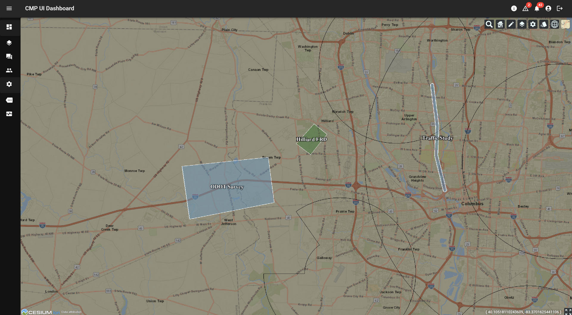
Columbus, OH – CAL Analytics, in coordination with the Ohio Department of Transportation (ODOT), has launched a low-altitude air traffic management system for drones to support statewide operations. As the number of uncrewed aircraft systems (UAS), or drones, grows, a robust system for managing the low-altitude airspace where these aircraft operate is necessary to ensure safety. While the Federal Aviation Administration (FAA) provides air traffic control for traditional aircraft flying in certain airspaces, low-altitude traffic management for drones is the responsibility of individual operators. Currently, drone pilots are required to keep the aircraft within sight to avoid a collision. A UAS Traffic Management (UTM) system enhances safety by enabling sharing of flight details between UAS operators, providing a digital tool for flight planning, and allowing operators to eventually operate beyond visual line of sight (BVLOS) while continuing to minimize the risk of collision. “The introduction of this vital capability continues Ohio’s tradition of innovation in the aviation community while prioritizing safety,” said Rich Fox, director of the Ohio UAS Center at ODOT. “As we collaborate with others at the newly opened National Advanced Air Mobility Center of Excellence, we expect this to be the first of many industry-leading activities coming out of that state-of-the-art facility.” Following several state sponsored research efforts to determine the best way to develop and deploy traffic management for uncrewed aircraft in Ohio, this system, implemented by CAL Analytics, provides interoperability where any user can enroll to share and receive flight information. As drone technology continues to advance, traffic management will be a key enabler of BVLOS operations, which currently require special permission from the FAA once stringent safety requirements are met. “We couldn’t be more thrilled to continue our collaboration with ODOT by deploying this discovery and synchronization services to fully realize this first of a kind operational UTM capability throughout the state of Ohio,” said Dr. Sean Calhoun, managing director of CAL Analytics. “This realization is the result of a lot of industry development, including the essential work from The Ohio State University research team and sponsored research from the Ohio Federal Research Network (OFRN). We are looking forward to working with the various interested stakeholders throughout the state and the FAA to learn from this system and to start scaling UAS operations throughout Ohio.” ODOT and the City of Hilliard will be the first organizations to enroll in the system and begin exchanging information as they look to leverage UAS as a tool for everything from inspection and traffic monitoring to onsite situational awareness for first responders, such as police and fire department dispatches. “Hilliard is excited to leverage this and other airspace services that Ohio has established to enable our first responder drone operations” says Deputy Police Chief for Hilliard, Ron Clark. “These services will be critical for us to achieve FAA approval and operate our drones in a safe and effective manner.” In the coming years, more advanced and BVLOS drone operations will increase in Ohio, which means multiple operators may be flying in the same area to deliver medical supplies, perform emergency services, conduct infrastructure inspections, and even deliver commercial packages. For safe and successful scaling of commercial drone operations, it’s imperative that pilots have situational awareness for strategic deconfliction. While both private and public organizations can enroll in the traffic management system, this resource is particularly valuable for other state agencies and local governments across Ohio. These services are available at no cost to any operator or fleet manager that requests access and goes through the onboarding process. To learn more or request access, please contact CAL Analytics at info@calanalytics.com.